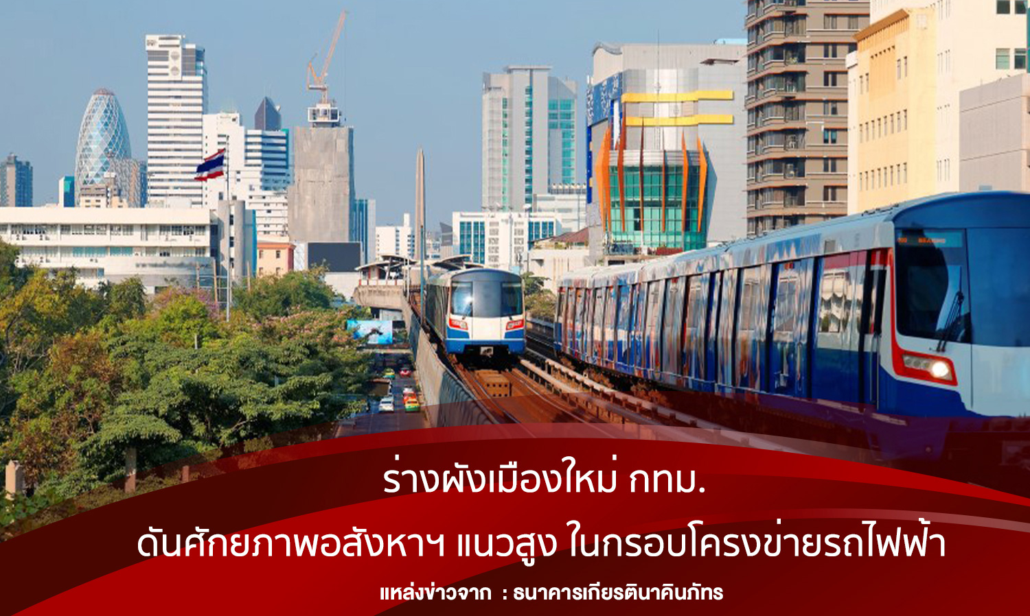
New Bangkok City Plan Unveiled to Boost High-Rise Real Estate Potential Along Transit Lines
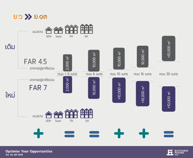
The upcoming changes to the Bangkok Master Plan will significantly impact real estate development, making it more appealing. This includes urban expansion and increased prosperity, enhancing residential development areas both horizontally and vertically, and increasing the Floor Area Ratio (FAR) to allow for greater density throughout Bangkok.
According to the Business Credit Division of Kiatnakin Phatra Bank, an analysis of the changes in the Bangkok Master Plan has been conducted, focusing on zones that will see increased potential for high-rise real estate development. This analysis will highlight which areas will become more attractive post-revision of the master plan.
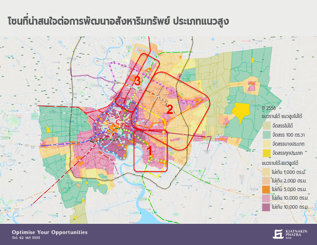
Figure 1 shows the zones analyzed for their potential in real estate development.
The zones selected for analysis are those that exhibit the most interesting changes, particularly within the framework of the upcoming transit lines extending from the north to the east, covering parts of the Green Line, Orange Line, Yellow Line, and Pink Line. The development guidelines promote these areas as New CBDs due to significant public investment and suitable facilities for comprehensive growth, aiming to distribute development beyond just the city center.
In some areas, plans have been made to increase residential density, as these locations provide convenient access to job centers and commercial areas in the city center through improved public transport systems. This enhances the potential for high-rise real estate development to accommodate the growing population. For instance, some areas that previously allowed for residential buildings with a usable area of only 2,000 square meters per building can now increase to a maximum of 10,000 square meters per building, with some areas even exceeding 10,000 square meters.
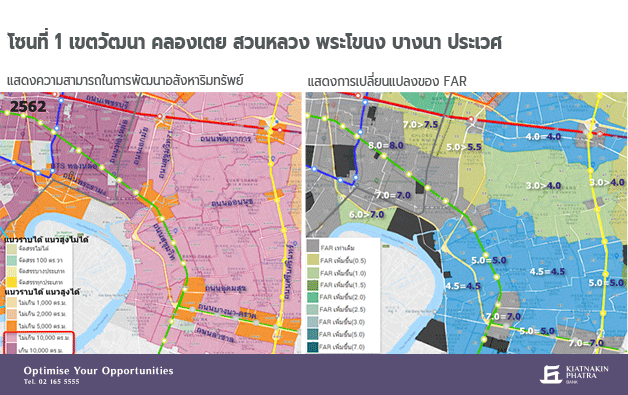
Zone 1: Watthana, Khlong Toei, Suan Luang, Phra Khanong, Bang Na, Prawet
This zone is a densely populated residential and commercial area, serving as a major tourism and business hub stretching from Asoke Intersection along Sukhumvit Road to Ekkamai Road. Changes in this area are minimal due to its already high density. However, noticeable developments are occurring in areas adjacent to the inner city, with medium-density community expansions along the Green Line on Sukhumvit Road extending to the Yellow Line on Srinakarin Road. This aims to expand residential areas for city workers, increasing the potential for high-rise land development and enhancing FAR for greater density.
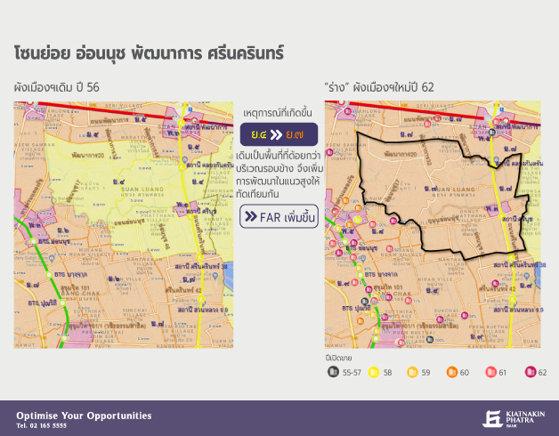
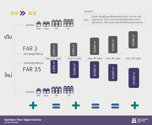
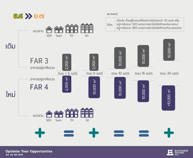
The areas of interest for high-rise real estate development in this zone will be along On Nut Road to Srinakarin Road and in the Phatthanakan area that connects to On Nut Road, including all sub-sois in On Nut. The land previously designated as yellow Y.4 in the old master plan will change to orange Y.7 in the new draft, increasing the potential of this land to match the surrounding areas that were previously designated as orange.
The image shows that condominium developments are currently limited to the orange areas in the old master plan, around various Green Line stations, and along the main roads frequented by locals. However, On Nut Road has seen minimal condominium development due to most of it being in the yellow area, where the old master plan restricted development to buildings that must be adjacent to major roads of at least 10 meters wide.
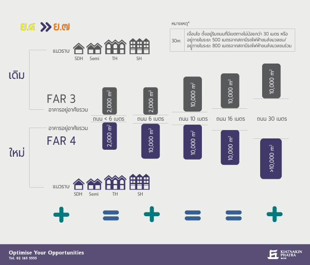
When comparing the requirements for the yellow Y.4 area changing to orange Y.7, it is evident that the land potential in the sub-sois of Phatthanakan and On Nut, which are between 6 and 10 meters wide, has improved. They can now develop condominiums with a usable area of up to 10,000 square meters per building, compared to only 2,000 square meters previously. According to construction regulations, if the road in front of the land is less than 10 meters wide, buildings cannot exceed 23 meters in height, limiting development in these smaller soi to a maximum of 8 stories. The FAR in this area has increased to 4:1, sufficient for low-rise project development.
The orange Y.7 area also includes land adjacent to Srinakarin Road, which is approximately 30 meters wide, and land within a 500-meter radius from the Yellow Line station (expected to open around 2021) that is adjacent to roads wider than 10 meters. This will enhance the potential of the land in these areas to develop large buildings, allowing for the construction of high-rise condominiums with usable areas exceeding 10,000 square meters per building. However, due to the limited FAR, land sizes of approximately 2 rai or more will be necessary to exceed 10,000 square meters per building.
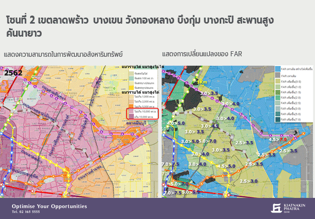
Zone 2: Lat Phrao, Bang Khen, Wang Thonglang, Bueng Kum, Bang Kapi, Saphan Sung, Khan Na Yao
This zone shows a strong trend towards improved public transport systems, surrounded by several transit lines including the Yellow, Orange, Pink, and Green Lines. It also extends from the inner city, enhancing the land potential along Rama 9 Road, Lat Phrao Road, and Ram Inthra Road for denser residential community development. Previously, this area was primarily a low-rise residential community with moderate density, thus increasing the potential for high-rise development and adjusting the FAR accordingly. Additionally, the junctions of transit stations or intersections with main roads will see increased commercial zones, with land in this area needing to be close to transit stations within the new master plan's radius or adjacent to major roads for optimal development.
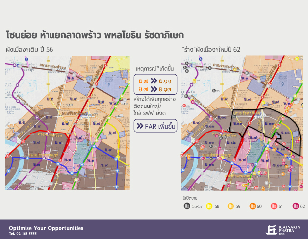
This sub-zone is particularly interesting for high-rise real estate development as it extends the growth from Ratchadapisek Road and Phahonyothin Road along the land within the boundaries of Lat Phrao Road, Ram Inthra Road, and Prasert Manukitch Road. With improved transportation and community density, the area is transitioning from yellow Y.4 in the old master plan to orange Y.6-9 in the new draft, significantly enhancing the potential for high-rise real estate development. The red P.1 area has also been upgraded to P.5, benefiting from proximity to upcoming transit stations, allowing for larger buildings to be constructed.
Despite the area having comprehensive facilities suitable for living, there has been minimal condominium development. Currently, only low-rise condominiums are being developed in the orange areas that provide access to the Blue Line (MRT) and Green Line stations or along major roads, such as Chokchai 4 Road, Lat Phrao-Wang Hin, Nakniwas, and Lat Plakhao. Due to the old master plan designating this area as yellow, developing condominiums that appear worthwhile must be along roads at least 10 meters wide. However, with the new master plan's changes and the completion of the Yellow and Pink Lines, the land potential in this area will improve.
In this sub-zone, the first area of interest will see a change in land potential from yellow Y.4 to orange Y.6-9 according to the new master plan, allowing for the construction of residential buildings with a maximum area of 10,000 square meters per building in small sois starting from just 6 meters wide, compared to the previous requirement of being adjacent to roads at least 10 meters wide. For example, in most areas transitioning to Y.6, land in the sub-sois leading from Chokchai 4 Road, Lat Phrao-Wang Hin, Nakniwas, and Lat Plakhao that can connect to transit stations can now develop low-rise condominiums with a maximum area of 10,000 square meters per building, up from only 2,000 square meters previously.
Land within a 500-meter radius from the Yellow and Pink Line stations currently under construction, adjacent to major roads of at least 10 meters wide, such as Lat Phrao Road, Mailap, or land adjacent to roads wider than 30 meters, such as Ram Inthra, Prasert Manukitch, and Pradit Manutham, can develop large buildings exceeding 10,000 square meters per building. However, with limited FAR, high-rise developments exceeding 10,000 square meters should ideally be on land of at least 2 rai.
The orange Y.6-9 area will have conditions regarding road size and distance from transit stations related to building size, with the only difference being the increased FAR of 3.5, 4.0, 4.5, and 5.0 respectively. This means that at the beginning of Chokchai 4 Road and Sankomsongkhrak Road extending to the start of Lat Phrao Wang Hin Road, areas changing to Y.9 will see the highest FAR increase of up to 5:1.
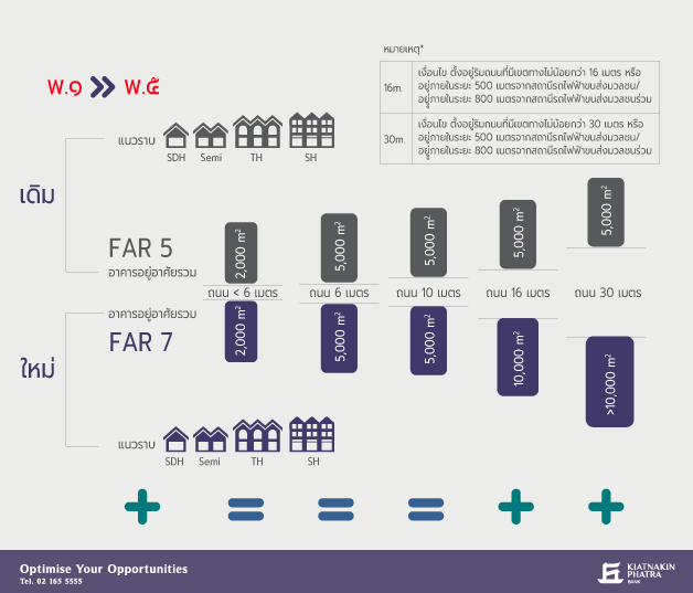
Another interesting area in this sub-zone is the red area transitioning from P.1 to P.5 along Lat Phrao Road near Chokchai 4 Market, which is within a 500-meter radius of transit stations and adjacent to roads wider than 30 meters. This area will develop into large buildings exceeding 10,000 square meters per building, with an FAR of up to 7:1, sufficient for high-rise condominium development.
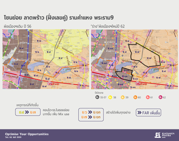
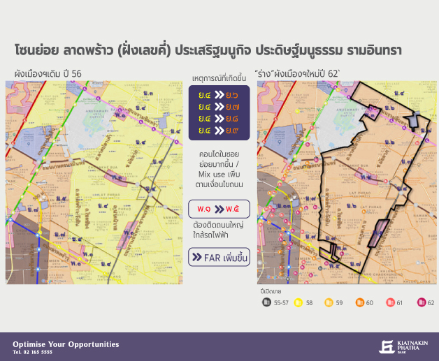
In this sub-zone, areas of interest are located around the southern side of Lat Phrao Road (even-numbered side) that connects to Sutthisarn, Huai Khwang, and Ramkhamhaeng. These areas will transition from yellow Y.4 to orange Y.7. This area is an existing residential community where most roads are less than 10 meters wide. Under the old yellow area regulations, development was limited to a maximum of 2,000 square meters per building, making it less attractive for investment.
Currently, there has been no condominium development in this area, despite having suitable facilities for living. Development has only reached the orange areas in the old master plan. The new master plan expands the orange areas to accommodate denser residential development along the transit lines, particularly in the New CBD area along Rama 9 Road, which will transition to brown Y.13, marking an expansion of the inner city along the Orange Line, as this area is currently experiencing significant growth as a commercial and employment hub.
The sub-zone discussed will see a transition from yellow Y.4 to orange Y.7, enhancing the overall land potential. This sub-zone can be divided into three areas of interest:
1. Land on the inner side of Ratchadapisek Road crossing over Lat Phrao Canal, which can connect to Lat Phrao and Pradit Manutham Roads, enhancing the land potential. Although the actual road size in this area is mostly less than 10 meters wide, the new master plan allows for larger condominiums with a maximum area of 10,000 square meters per building, developing low-rise condominiums in sois that can access the Blue Line (MRT) at Sutthisarn and Huai Khwang stations.
2. All land along Lat Phrao Road near the Yellow Line stations within a 500-meter radius and along Pradit Manutham Road that is 30 meters wide can develop high-rise condominiums into large buildings exceeding 10,000 square meters per building.
3. Land in sois connecting from Lat Phrao Road to Ramkhamhaeng, such as Siwara Road, Soi Ramkhamhaeng 43/1, and Soi Mahadthai (Ramkhamhaeng 65), which are relatively dense communities. Once the Yellow Line on Lat Phrao Road and the Orange Line near Ramkhamhaeng are completed, the land in these smaller sois, which are less than 10 meters wide, will become more suitable for living due to improved accessibility, allowing for the development of low-rise condominiums with a maximum area of 10,000 square meters per building, compared to only 2,000 square meters previously.
The next sub-zone is land along Rama 9 Road, transitioning from orange Y.6 to brown Y.13, from the RCA city plan intersection to Soi Research Center and Pradit Manutham Road along the Orange Line. This area will expand to accommodate commercial centers and increased density moving out from the inner city, with an FAR increase of up to 7:1. The most interesting land will be those adjacent to roads wider than 10 meters, as this land will enhance the potential for high-rise condominiums exceeding 10,000 square meters.
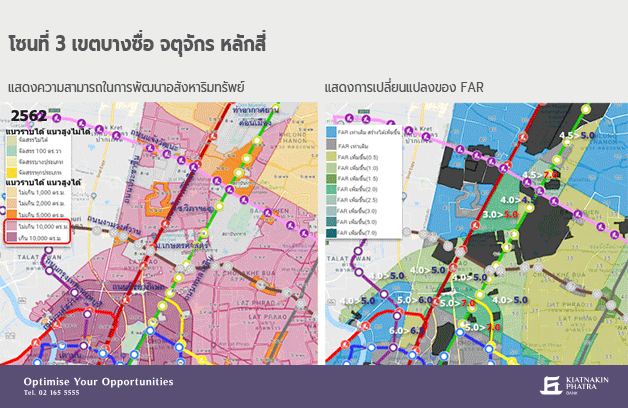
Zone 3: Bang Sue, Chatuchak, Lak Si
This zone will extend commercial areas and communities from the city center along Ratchadapisek Road to the Bang Sue and Chatuchak stations, increasing density to accommodate growth along the transit lines with a central mega project station and community expansions along the Green Line heading north to Ram Inthra-Don Mueang, where FAR will increase along the way. The land potential will improve significantly if located within the radius of transit stations, especially at junctions where commercial development will increase.
The areas of interest for high-rise real estate development in this zone will be from the Lat Phrao intersection along Phahonyothin Road in line with the Green Line, transitioning from orange Y.7 to brown Y.13 in the new master plan. This will significantly enhance the land potential in this area, as long as the land is adjacent to roads wider than 10 meters, allowing for the construction of high-rise condominiums that are large buildings according to the increased FAR, without needing to be adjacent to major roads that must be at least 30 meters wide or within 500 meters of transit stations as per the old master plan.
As seen in the images, currently, condominium developments are limited to areas along Phahonyothin Road, which is approximately 32 meters wide (road width data from the Bangkok Metropolitan Administration). However, if the new master plan is enforced, it is expected to lead to increased condominium developments in main sois that are at least 10 meters wide.
The transition from orange Y.7 to brown Y.13 will improve the land potential in this area due to the increased FAR of up to 7:1, aligning with the enhanced development potential without limiting building size. However, construction regulations state that to develop large buildings not exceeding 30,000 square meters, the land must be adjacent to roads wider than 10 meters, while for buildings exceeding 30,000 square meters, the land must be adjacent to roads wider than 18 meters and have a minimum width of 12 meters. This means that land in the main sois of Phahonyothin Road, Ratchadapisek Road, and Prachachuen Road in this area, with road widths of at least 10 meters, has significantly improved potential, as previously, development was limited to no more than 10,000 square meters per building.
If the land can access the Green Line at the Lat Phrao intersection, Phahonyothin 24, and Ratchayothin stations currently in service, it will become increasingly attractive for high-rise condominium development.
Overall, the land in the various zones analyzed has increased potential for high-rise real estate development due to the expansion of prosperity from the city center, which serves as a business, commercial, and employment hub. This increases both brown areas intended to accommodate residential development in the inner city and orange areas aimed at supporting the expansion of residential development in areas adjacent to the inner city.
All of these will be within the service areas of the public transport system, both those already in operation and those under construction. Additionally, this area was previously a densely populated low-rise residential community, thus enhancing the land potential for increased density in high-rise developments. Although the land has increased potential for real estate development, it is advisable to study market conditions, popular product types in the area, and appropriate price levels before proceeding with real estate development.
Reference: Kiatnakin Phatra Bank : https://bank.kkpfg.com/th/home