
“Live with Flood” Adapting to a Changing Climate
By Mr. Prabhan Sak Raksaiwan
Managing Director
LWSS Wisdom and Solutions Co., Ltd.
Hello October, TerraBKK members! How are you all doing? This year, the floods arrived early due to the La Niña phenomenon, causing a rapid increase in water levels and resulting in natural disasters such as flooding in the northern and northeastern regions. Many areas have suffered damage, affecting numerous provinces since September, and there are still warning signs to monitor in October.
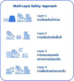
This situation is not unique to Thailand; it is happening worldwide as a result of climate change, leading to increasingly severe natural disasters each year. In response to these challenges, various agencies have collaborated to explore adaptive strategies to combat natural disasters and minimize losses. One such initiative is the FRAMES (Flood Resilient Areas by Multi-layered Safety) project, a partnership among five countries: Germany, the Netherlands, England, Denmark, and Belgium, based on the concept of Multi-Layer Safety (MLS) which consists of four layers:
Layer 1 - Flood Prevention
The first layer focuses on “keeping water away from people” to prevent disasters from occurring in the first place. For areas along riverbanks or coastlines that have a history or risk of flooding, prevention methods often involve constructing walls or creating barriers to keep water from overflowing into residential areas. However, this can disrupt the way of life for riverside communities, making it suitable only in certain locations.
Building large dams to control water levels can also generate electricity or serve as public spaces while storing water for dry seasons. However, this comes at the cost of losing large forest areas for water retention, impacting wildlife and ecosystems, and requiring significant investment and cooperation from government agencies for maintenance.

Layer 2 - Spatial Adaptation
This layer emphasizes “keeping people away from water”, which can be achieved through community or urban design in flood-prone areas. Residents are well aware that they will face similar events every year around the same time. Architectural designs often include elevated houses with space underneath to stay above water levels or two-story homes where the ground floor serves as a garage equipped with flood-proof doors to protect vehicles.
In landscape architecture, creating water retention areas to manage excess water can also provide resources during dry spells. This involves designing green spaces or structures to maximize water collection, such as activity areas, pathways in parks, ponds, or retention basins.
An example is the design of the 100-Year Park at Chulalongkorn University, where one side of the park is sloped to collect rainwater. Additionally, the wetland area beside the park can accommodate rainwater. The hard surface areas use porous concrete to allow water to seep into the ground, and a drainage system without pipes is designed with small plants to absorb excess rainwater, maximizing water utility. Community members can also contribute by cycling to increase oxygen levels in water sources, designed as “Chai Pattana Water Turbines,” part of a royal initiative by King Rama IX that also helps treat wastewater.
Layer 3 - Emergency Response
This layer aims to reduce the impact of flooding through a comprehensive management system utilizing technology, from community-level planning to individual family units. Following the MLS approach, the project has developed a decision-support system for government agencies to create flood risk management plans.
An example is the flood simulation in Zeeland, Netherlands, part of the EU Interreg FRAMES project, which created a 3D model of the city to assess flood impacts in vulnerable areas, including infrastructure like roads, tunnels, and railways. The pilot project produced risk maps and designed an app to alert users about flood threats based on their location, informing them of risks, impacts, and evacuation possibilities, integrating technology into management systems.
Layer 4 - Rapid Recovery
This step involves preparing the actual area following Layer 3, assessing the community's recovery capacity, and identifying opportunities for preparedness, response, and recovery from flooding through policy tools and regulations, including comprehensive maps, hazard mitigation plans, and local land use regulations. This includes preserving areas along river corridors, planting flood-resistant crops, and setting flood base levels to ensure buildings in flood zones are elevated above those levels. Additionally, community members must be knowledgeable about evacuation routes and safe meeting points to ensure assistance can reach them quickly.
The MLS principles continue to enhance flood resilience in various pilot project areas, benefiting long-term planning efforts and strengthening measures across all four layers. This approach aims to integrate strategies that not only focus on prevention but also consider land use planning and suitable recovery points.
The four-layer approach is a crucial principle that can be adapted in Thailand. According to a study by the Stockholm Environment Institute (SEI), an international non-profit research institute addressing environmental and sustainable development challenges, a report published in May 2023 summarized the flooding situation in Thailand and proposed solutions as follows:
- Improved Flood Warning Systems
The existing early warning systems are insufficient to cope with the frequent flash floods in the area, especially during the major flooding event in November 2021 when sirens were delayed. Prolonged heavy rain raised water levels, and the severity and suddenness of the flooding overwhelmed the early warning systems, causing significant damage in downtown Mae Sai, with losses estimated at half a million dollars.
The assessment developed by SEI in collaboration with researchers from Mae Fah Luang University ultimately led to improved forecasting for the region. The early warning sirens have been supplemented with an app developed with input from SEI researchers, but this is just the beginning of what can be done to address flood risk in the region.
- Modeling to Support Decision-Making
A research project by Mae Fah Luang University, in collaboration with the National Water Resources Office, provided a report with baseline information on water resources, economy, society, and cross-border cooperation in the region. The research team assisted Mae Sai Municipality in identifying locations for hydrometric stations in five watersheds to monitor rainfall and water levels. The Mae Sai mayor emphasized that a better understanding of flood patterns would help mitigate flood risks, and cooperation between agencies on both sides of the Thai-Myanmar border is crucial for effective flood risk management.
- Improved Apps for Flash Flood and Drought Alerts
The Usurapong application provides localized weather and water level information, along with guidance from government agencies and reporters in both Thai and Burmese, based on data from Thailand. It has been downloaded over 1,000 times since its launch in May 2022 and is one of the main strategies to improve flood response, enhancing the accuracy of alerts and educating the public on disaster preparedness.
- Working Towards Future Resilience
Apps and early warning systems can help reduce damage from flash floods, but additional supportive measures are necessary. SEI researchers have developed hydrological models for decision-support systems in water management, enabling public participation in official water and flood management plans. The team plans to simulate land use changes related to climate change forecasts to enhance community resilience to future flooding.
This project is part of SEI's broader efforts to reduce disaster risk and enhance climate change resilience in Southeast Asia. It is evident that this year, the systems are still inadequate to cope with major floods, and many provinces continue to be widely affected. It is hoped that collaboration among all sectors will help develop systems that allow Thai citizens to combat increasingly severe floods safely, protecting lives and property.

While we cannot avoid natural disasters, being prepared for situations can help mitigate the damage caused. I believe that technology has developed to a level where it can provide alerts and help alleviate damage when all parties cooperate.
I wish everyone the best during this time, and I look forward to seeing you in November.
Best regards,