Revealing the Secrets of Digital Twin: The Unsung Heroes Behind the Tham Luang Cave Rescue on Its 4th Anniversary
Back in July 2018, the world watched closely as the Wild Boar soccer team was rescued from Tham Luang Cave in Chiang Rai. The heroes of this rescue operation were a collaboration of experts in various fields including rescue specialists, divers, drillers, geologists, climbers, police, military personnel, and officials from both Thailand and abroad. Tragically, some even lost their lives during this operation, but ultimately, all 13 members of the Wild Boar youth soccer team survived.
Amidst the heroes working on the ground, there was another team of heroes utilizing technical knowledge of Digital Twin to create a model of the cave for planning the rescue.

At that time, the Department of Mineral Resources (DMR) collaborated with Esri Thailand Ltd. and GIS Ltd. to create a Digital Twin of the cave, simulating various scenarios to develop a suitable map that would serve as a guide for the rescue operation inside the cave. This included simulations of potential flooding scenarios due to heavy rainfall outside and cave drilling simulations.
The entire operation was conducted urgently, racing against time, with almost no existing data. It was essentially a complete reconstruction of the Digital Model of the Map.
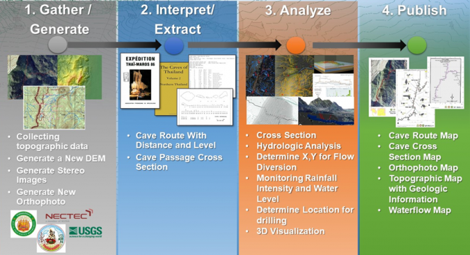
In addition to the DMR, coordination was also made with the National Parks Department to work together. The entire process, including the simulation of maps showing water flow in the cave accumulated from rainfall (as illustrated), typically takes months or even years, but for this mission, it was completed in just a few days.
Cr. Picture : www.gim-international.com/content/article/the-behind-the-scenes-story-of-the-thailand-cave-rescue
The working process began with data collection, focusing on critical areas needed for the rescue, requiring detailed information while other aspects were simplified for usability. Maps from the military mapping department dating back to 2017 were utilized, along with maps from the “Expedition Thai-Maros 1986 and 1987” created by a French team.
Later, the team discovered the “Cave Registry Data Archive” from the British Cave Association, which contained exploration data from 2014-2015 in SRV file format. During this time, a 3D Model was being developed by the team in parallel, allowing all team members to view updates as the model progressed.
All of this significantly improved the efficiency of the divers' operations, especially in the initial phase, where they were diving back and forth to gather data on various routes.
The fluctuating water levels in the cave due to rainfall were a crucial factor in planning the divers' rescue efforts. Changes in water levels would affect the amount of oxygen the divers needed to prepare. If the survey data was inaccurate, it could delay the rescue operation.
This meant that the lives of the children trapped inside the cave would be at greater risk.
During the rainy season, when the incident occurred, heavy rainfall caused significant flooding in the cave, complicating rescue efforts. Initially, attempts were made to install water pumps, but it was found that their capacity was insufficient compared to the amount of rainfall.
The successful tools for controlling the rising water levels included connecting pipes and constructing temporary dams to slow down flooding within the cave. These two elements were utilized throughout the rescue operation.
Thus, the solution required rerouting the water, which meant drilling into the cave. Determining the most effective drilling points relied on Digital Twin to simulate conditions and pathways of the cave for analysis, including a Water Flow Simulation to compare the results of drilling at various points. Without the 3D Model that is Digital Twin, such simulations would not have been possible, and drilling would have been based on guesswork.
Ultimately, the team discovered the optimal drilling point, confirmed by the SEAL unit who experienced the water currents inside.
The outcome of creating the Simulation Model confirmed that if water were removed from the cave, it could amount to 10,000 Cubic Meters, which would greatly benefit the operation to access the interior.
However, in the final moments, the divers decided not to wait for drilling, as they needed to prepare additional equipment, and opted to dive in directly to assist.
On the actual day of diving to rescue all the children, the Digital Twin team still had work to do, which was to monitor rainfall data that would affect water levels in the cave and communicate this information continuously.
The data came from the National Electronics and Computer Technology Center (NECTEC). As everyone knows, the rescue was successful, and part of that success was attributed to the use of Digital Twin technology and the team of experts working behind the scenes.
Key Lessons Learned
(1) Any operation in an unfamiliar area where no one knows the “map” is crucial. In environments with elevation changes (Z-axis), a 3D map is essential for utility.
(2) Data can come from various eras and must be shared for maximum benefit.
(3) Purpose must come before technology - we use technology to reduce risks for the divers and create the most diverse plans in the shortest time. We do not aim to showcase technology as the hero. Some technologies may be beneficial, such as modeling water extraction from the mountain, but if they are not timely or do not meet the objectives at that moment, they should not be pursued.
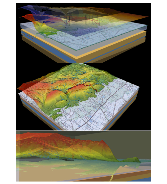
The Digital Twin of the cave that was created
References for the story and images
www.gim-international.com/content/article/the-behind-the-scenes-story-of-the-thailand-cave-rescue
www.gim-international.com/content/article/the-behind-the-scenes-story-of-the-thailand-cave-rescue